


Canyonlands National Park
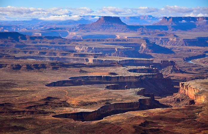
Canyonlands National Park is a spectacular landscape of deep canyons, towering sandstone formations, mesas, and buttes carved over millions of years by the Colorado and Green Rivers. Located in southeastern Utah, the park encompasses more than 337,000 acres of rugged desert terrain and is divided into four distinct districts, each offering unique viewpoints and outdoor adventures. Renowned for its breathtaking vistas, colorful red-rock scenery, and remote wilderness, Canyonlands showcases some of the most dramatic and unspoiled landscapes in the American Southwest.
My Favorite Hikes for Photography
If you're carrying a camera, a few trails stand out above the rest. The best hikes in Canyonlands National Park offer a combination of breathtaking scenery, unique geological features, and unforgettable viewpoints. Mesa Arch Trail is a short, easy hike leading to the park's most iconic landmark, where photographers gather at sunrise to capture the arch glowing above a vast canyon landscape. Grand View Point Trail follows the canyon rim and provides sweeping panoramas of mesas, buttes, and deep canyons, making it one of the park's premier scenic walks. White Rim Overlook Trail is a relatively short hike that rewards visitors with dramatic views of the White Rim sandstone bench and the rugged terrain carved by the Colorado River. Murphy Point Trail offers a quieter experience with expansive vistas, towering cliffs, and spectacular sunset photography opportunities. Upheaval Dome Overlook Trail leads to one of the park's most fascinating geological mysteries, providing overlooks of a massive crater-like formation surrounded by colorful canyon country. For those seeking a more challenging adventure, Druid Arch Trail in the Needles District winds through striking red-rock landscapes before reaching a massive arch that resembles an ancient stone cathedral, making it one of Canyonlands' most rewarding hikes.

Mesa Arch Trail
Difficulty: Easy
Distance: 0.7 miles round trip
Mesa Arch is Canyonlands' most famous photography location and one of the most photographed spots in Utah. This short loop trail leads to a dramatic arch perched on the edge of a cliff overlooking a vast canyon. At sunrise, the underside of the arch glows a brilliant orange-red, creating an iconic image that attracts photographers from around the world. Despite its popularity, the panoramic views of the canyons and distant La Sal Mountains make it a must-visit.

Grand View Point Trail
Difficulty: Easy to Moderate
Distance: 1.8 miles round trip
Located at the southern end of the Island in the Sky district, Grand View Point Trail follows the canyon rim to a spectacular overlook. Along the route, photographers are treated to sweeping views of mesas, buttes, deep canyons, and the White Rim. The trail is especially rewarding during sunrise and sunset when warm light enhances the rich colors and textures of the landscape.
White Rim Overlook Trail
Difficulty: Moderate
Distance: 1.8 miles round trip
This relatively short trail leads to one of the park's most dramatic viewpoints. From the overlook, visitors can photograph the expansive White Rim sandstone layer stretching across the landscape below. The elevated perspective provides excellent opportunities for capturing the scale and rugged beauty of Canyonlands, particularly during the golden hours of the day.

Murphy Point Trail
Difficulty: Moderate
Distance: 3.6 miles round trip
Murphy Point offers one of the best photography experiences in Canyonlands with far fewer crowds than Mesa Arch or Grand View Point. The trail traverses open desert terrain before reaching a dramatic cliff-edge overlook. From the viewpoint, photographers can capture sweeping canyon vistas, towering rock formations, and exceptional sunset light that often paints the landscape in vivid shades of red and gold.

Upheaval Dome Overlook Trail
Difficulty: Moderate
Distance: 1.8 miles round trip (to the Second Overlook)
This trail leads to a unique geological formation known as Upheaval Dome, a mysterious circular depression believed to have been formed by either a meteor impact or a salt dome uplift. The trail offers several viewpoints overlooking the formation and surrounding canyons. Its unusual geology and elevated vistas make it a favorite among landscape photographers looking for something different from the park's typical canyon scenes.