


Best Hikes in Bryce Canyon National Park
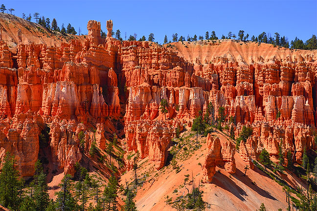
Nestled along the edge of the Paunsaugunt Plateau in southern Utah, Bryce Canyon National Park is famous for its breathtaking collection of hoodoos—tall, colorful rock spires sculpted by millions of years of frost and erosion. The park's natural amphitheaters, dramatic overlooks, and winding canyon trails create one of the most unique landscapes in the world. Visitors can enjoy scenic drives, panoramic viewpoints, and hikes that descend among the towering formations, offering unforgettable perspectives of the canyon's vibrant red, orange, and white rock layers. From sunrise and sunset photography to stargazing beneath some of the darkest skies in the country, Bryce Canyon delivers an unforgettable outdoor experience in every season.

The Rim Trail
Difficulty: Easy to moderate
The Rim Trail is one of the most scenic and accessible hikes in Bryce Canyon National Park. Following the edge of the Bryce Amphitheater, the trail offers continuous views of the park's famous hoodoos, colorful rock formations, and dramatic canyon landscapes. Visitors can hike short sections between viewpoints or explore longer stretches of the trail while enjoying breathtaking overlooks such as Sunrise Point, Sunset Point, Inspiration Point, and Bryce Point. It's an excellent hike for photographers, especially during sunrise and sunset when the hoodoos glow with vibrant shades of red, orange, and gold.
The Rim Trail is a scenic, moderately long but easy hiking route that follows the edge of the Bryce Amphitheater with minimal elevation gain (under 200 feet in most sections). It stretches along the canyon rim from Fairyland Point in the north, passes the Bryce Canyon Lodge area, and continues south to Bryce Point. The trail forms a sweeping crescent-shaped route that offers constantly changing perspectives of the same iconic formations from different viewpoints along the rim.
-
Trailhead: 37.649463, -112.147767
-
Trail Type: Hiking
-
Length: 4.7 miles one way
Most of the major trails in Bryce Canyon begin along the rim, making it easy to combine sections of the Rim Trail with popular loop hikes. While Fairyland Point is considered the northern trailhead, hikers can easily start from Bryce Point or any of the main viewpoints depending on their itinerary. If you hike the full one-way route, you will need a shuttle or arranged transportation to return to your starting point.
Fairyland Point
Fairyland Point marks the northern end of the Rim Trail and offers a quieter, more remote viewpoint compared to the busier central area of the park. From here, you can see Boat Mesa, Fairyland Canyon, the Sinking Ship, and Campbell Canyon. It also serves as the trailhead for the Fairyland Loop Trail, making it a great starting point for longer hikes. Because it sits away from Sunrise, Sunset, and Inspiration Points, it provides a more isolated and expansive perspective of the Bryce landscape.
Sunrise Point
Sunrise Point sits near the central section of the Rim Trail, just east of Bryce Canyon Lodge and slightly above Sunset Point. It also serves as the starting point for the Queens Garden Loop Trail. From here, hikers have wide open views of the Bryce Amphitheater along with formations such as the Queen’s Garden, the Sinking Ship, Boat Mesa, and distant hoodoos stretching across the canyon.
Sunset Point
Sunset Point lies just below Sunrise Point and is one of the most popular viewpoints along the Rim Trail. It is the trailhead for the Navajo Loop Trail, which descends into some of the most famous sections of the canyon. From Sunset Point, you can see Thor’s Hammer, the Silent City, and the upper sections of Wall Street, along with sweeping views across the amphitheater.
Inspiration Point
Inspiration Point sits along the western stretch of the Rim Trail and offers a dramatic elevated view directly across the amphitheater. While there are no major trails that begin here, it provides one of the best vantage points for seeing the layered hoodoos and formations around Bryce Point, Sunrise Point, and Sunset Point all at once.
Bryce Point
Bryce Point marks the southern end of the Rim Trail and connects to the broader Under-the-Rim Trail that extends deeper into the park. It also serves as the trailhead for the Peekaboo Loop Trail, which drops into the canyon and winds through formations such as the Cathedral, the Alligator, and beneath the Wall of Windows. Bryce Point is widely considered one of the most dramatic viewpoints in the entire park due to its elevation and wide-angle perspective of the amphitheater.


The Mossy Cave Trail
Difficulty: Easy
The Mossy Cave Trail is a short and family-friendly hike located just outside the main Bryce Canyon National Park entrance. Unlike many of Bryce's rim-top trails, this unique walk takes visitors down into a small canyon where they can enjoy a seasonal waterfall, a flowing stream, and the famous Mossy Cave. During the warmer months, the cave is covered with vibrant green mosses and hanging gardens, creating a beautiful contrast against the surrounding red rock cliffs. The trail is less than a mile round-trip, making it a great option for families, casual hikers, and photographers looking for an easy adventure with rewarding scenery. Early morning and evening light often provide the best photography opportunities along the trail.
The Mossy Cave Trail is located on the northern end of Bryce Canyon National Park and offers a short, easy hike that brings you up close to hoodoos, spires, and a seasonal stream without the need to descend into the main amphitheater. Unlike the longer, more strenuous canyon trails, this route stays relatively low in elevation and leads to a natural grotto known as Mossy Cave, a sheltered overhang that often holds icicles in the winter and moss and lichen during the warmer months. The combination of water, rock formations, and vegetation makes it one of the most unique short hikes in the park.
-
Trailhead: 37.666277, -112.10997
-
Trail Type: Hiking
-
Length: 1 mile round trip
Unlike most hikes in Bryce Canyon, the Mossy Cave Trail is not accessed via the main Bryce Canyon National Park entrance turnoff onto Highway 63. Instead, visitors coming from the west pass the main entrance and continue north along Highway 12 for about 4 miles toward Tropic, where the trailhead is located. This makes it feel slightly separate from the main park corridor and often less crowded.
The stream you see along the trail is actually part of the historic “Tropic Ditch,” an irrigation canal built by early settlers to supply water to the nearby towns of Tropic and Cannonville. Over time, this man-made water flow has influenced erosion in the area, carving out a small canyon system that differs from the naturally frost-wedged formations found elsewhere in Bryce Canyon.
MOSSY CAVE TRAILHEAD
About a quarter mile into the hike, the trail splits into two directions.
The right fork follows the stream northward and leads to a small seasonal waterfall, which is especially active in spring and early summer runoff. The left fork heads southwest and climbs gently toward the Mossy Cave itself, where the overhang creates a shaded alcove that stays cooler and damper than the surrounding desert landscape. Both forks are short and easy to explore, making it simple to experience both features in a quick visit.


Navajo Loop Trail
Difficulty: Moderate to Strenuous
The Navajo Loop Trail is one of Bryce Canyon National Park's most iconic hikes and offers visitors an up-close experience with the park's world-famous hoodoos. Beginning at Sunset Point, the trail descends into the heart of Bryce Amphitheater through a maze of towering sandstone spires, narrow switchbacks, and colorful rock formations. Highlights include the famous Wall Street section, with its towering cliffs and Douglas fir trees, as well as the impressive Twin Bridges formation. Although the hike is relatively short at approximately 1.3 miles, the steep climb back to the rim can be challenging due to the elevation and grade. The Navajo Loop is a must-do hike for photographers and visitors wanting to experience Bryce Canyon from both the rim and canyon floor perspectives. Early morning and late afternoon provide the best lighting for photography and cooler hiking conditions.
The Navajo Loop Trail is one of the most popular hikes in Bryce Canyon National Park, dropping visitors directly from the rim at Sunset Point into the heart of the Bryce Amphitheater. From the trailhead, the route descends steeply into a world of towering hoodoos, narrow canyon passages, and dramatic rock formations before looping back up to the rim at the same point. Along the way, hikers pass through iconic sections such as Wall Street, a tight slot-canyon-style corridor lined with towering walls of orange and pink limestone, and the Silent City, a dense cluster of hoodoos that looks like an ancient stone metropolis. The trail also connects with the Queens Garden Loop and approaches the area near the Peekaboo Loop junction, making it a central hub for some of the park’s most famous hiking combinations.
-
Trail Head: 37.623763, -112.167763
-
Trail Type: Hiking
-
Length: 1.3 miles round trip
The parking area for the Navajo Loop Trail is located just south of Bryce Canyon Lodge off Highway 63, with Sunset Point serving as the main staging area for the hike. From here, visitors are immediately treated to sweeping views over the amphitheater before beginning the steep descent into the canyon.
One of the most famous features of the trail is Wall Street, a narrow, towering corridor where the canyon walls rise sharply on both sides, creating a dramatic and enclosed hiking experience unlike anything else in the park. Another highlight is the Silent City, a dense grouping of hoodoos that resembles a natural skyline of stone spires packed closely together across the canyon floor.
Although the Navajo Loop is relatively short in distance, it is physically demanding due to the steep elevation change. Hikers descend roughly 800 feet into the canyon and then must climb that same elevation back to the rim, which is the most challenging part of the hike.
For those looking to extend the experience, the Navajo Loop connects directly with the Queens Garden Loop Trail, forming one of the most popular combined hikes in Bryce Canyon. It also connects near the base of the Peekaboo Loop Trail, allowing more adventurous hikers to continue deeper into the amphitheater for an even longer and more immersive route.

The Fairyland Loop Trail
Difficulty: Strenuous
The Fairyland Loop Trail in Bryce Canyon National Park is one of the park’s longer and more immersive hikes, circling through quiet northern sections of the canyon where you get a mix of rim-top views and down-in-the-hoodoos scenery. It starts either at Fairyland Point or near Sunrise Point, then follows the rim for a stretch before dropping down into Fairyland Canyon and wrapping around formations like Boat Mesa, Tower Bridge, and the China Wall. What makes it special is how it constantly changes perspective—you’re moving from open overlooks on the rim to narrow canyon sections surrounded by tall hoodoos, with very little of the heavy foot traffic you see on the main amphitheater trails. The full loop is about 8 miles round trip with roughly 1,500–1,900 feet of elevation gain and loss, so you’re dealing with a steady climb back out of the canyon at the end, which is usually the hardest part. The trail itself is well-defined and not technically difficult, but it’s exposed, long, and physically demanding—especially at Bryce’s high elevation and in the sun. In practical terms, it feels like a full half-day hike that requires endurance more than skill, and it’s best suited for hikers who are comfortable with sustained uphill sections and want a quieter, more remote experience compared to the busier Bryce Canyon trails.
The Fairyland Loop Trail is one of the most immersive and least crowded hikes in Bryce Canyon National Park, taking hikers from Fairyland Point on the rim down into the amphitheaters, labyrinths, and winding canyon systems below. The trail descends roughly 900 feet into the valley and then makes a wide, sweeping circuit around the base of Boat Mesa before weaving through Fairyland Canyon and Campbell Canyon. Much of the route stays low in the canyon bottoms, surrounded by tall hoodoos and layered cliffs in shades of pink, white, and tan, creating a long, quiet journey through some of the most sculpted terrain in the park.
-
Trail Head: 37.64981746916702, -112.14589892048379
-
Trail Type: Hiking
-
Length: 8.3 miles round trip
The hike begins at Fairyland Point, where the trail drops off the rim and quickly enters Fairyland Canyon. From there, it follows the canyon floor southward, passing beneath towering formations before reaching the broad base of Boat Mesa. Rather than continuing straight through the canyon junction, the trail curves around the mesa, climbing and contouring along its southern edge where Fairyland Canyon meets Campbell Canyon. This section offers some of the most isolated and expansive views on the route, with fewer hikers and a more remote feel compared to the central amphitheater trails.
One of the highlights along the way is Tower Bridge, a striking hoodoo formation framed by two natural arches carved into a large rock fin near the entrance to Campbell Canyon. Farther along the route, hikers encounter the China Wall, a long, elevated line of hoodoos that sits along a ridge and resembles a natural stone wall stretching across the landscape. This section is especially photogenic, with tightly packed formations rising in a continuous row above the trail.
As the loop continues westward, hikers begin the long climb back up toward the rim, gaining nearly 900 feet in elevation as they exit the canyon system. Near the upper section of the climb, the trail reaches an intersection where the loop turns north to return toward Fairyland Point. At this junction, hikers also have the option to detour west toward Bryce Canyon Lodge and the General Store before reconnecting with the loop. From there, the final stretch continues north along the rim back to the starting point at Fairyland Point, completing one of the most scenic and physically demanding loops in the park.
The Peekaboo Loop Trail
Difficulty: Strenuous
The Peekaboo Loop Trail in Bryce Canyon National Park is one of the park’s most immersive hoodoo hikes, dropping you straight from the rim at Bryce Point down into the heart of the Bryce Amphitheater and weaving through dense formations of arches, fins, and towering rock spires before climbing back out the same way. Unlike the rim walks, this trail puts you directly inside the canyon environment, so you’re constantly surrounded by shifting views—tight corridors of hoodoos, open basins where you can see miles of formations, and sections where the trail snakes beneath dramatic cliffs like the Wall of Windows and past formations such as Fairy Castle. It feels like a full “inside the landscape” experience rather than just looking down at it. The trail is about 5.2–5.5 miles round trip, with roughly 1,500–1,560 feet of elevation gain, meaning you descend steeply into the canyon at the start and then face a long, steady climb back up to Bryce Point at the end. The path itself is well-built and not technically difficult, but the constant up-and-down “roller-coaster” profile, high elevation, and sun exposure make it physically demanding. In practical terms, it’s a solid half-day hike for most people, best suited for those who are comfortable with steep climbs and want one of the most dramatic and up-close hoodoo experiences in the park.
The Peekaboo Loop Trail is an equestrian route in Bryce Canyon National Park that is also extremely popular with hikers looking for a more rugged and immersive canyon experience. The trail begins at Bryce Point, one of the most dramatic overlooks in the park, where sweeping views reveal the entire Bryce Amphitheater, including Sunrise Point, Sunset Point, and even Fairyland Point in the distance. From the rim, the trail drops steeply down the canyon wall in a series of switchbacks, losing nearly 1,000 feet in elevation as it descends into the hoodoos below. Once at the bottom, the route opens into a looping path through the interior of the amphitheater before reconnecting near the Navajo Loop Trail area. Many hikers complete it as an out-and-back from Bryce Point, which makes the return climb one of the most challenging but rewarding ascents in the park.
-
Trail Head: 37.60529, -112.157483
-
Trail Type: Hiking
-
Length: 5.5 miles round trip
Bryce Point itself offers one of the best panoramic viewpoints in Bryce Canyon National Park, with a full view across the amphitheater’s maze of hoodoos and canyons. From here, hikers can clearly see Sunset and Sunrise Point to the northwest, Fairyland Point far to the north, and the network of trails weaving through the canyon floor below. The descent begins along a ridgeline that stretches northeast from Bryce Point, where the trail repeatedly switchbacks down steep slopes and across narrow saddles carved into the canyon wall.
Along the way, hikers pass near formations such as The Alligator, a clustered mass of hoodoos that resembles the shape of its namesake when viewed from above. Farther into the loop, the trail reaches The Cathedral, a striking formation on a bluff at the northwest end of the route, where tall spires rise sharply against the sky. Another standout feature is the Wall of Windows, a delicate and heavily eroded fin of hoodoos that lines the slopes just west of Bryce Point and is often considered one of the most visually impressive sections of the entire trail.
While the loop can be completed as a circuit, many hikers also use this area to connect with the Navajo Loop Trail, continuing north toward Sunrise and Sunset Points for a longer traverse through the amphitheater. Whether hiked as a loop or combined with other trails, Peekaboo delivers one of the most physically demanding and visually rewarding experiences in Bryce Canyon.
Click here >>>> for Bryce Canyon Info

Safety Tips
Always tell someone where you are going and when you expect to return before heading out on any hike. Send a text, leave a voicemail, or share your plans with a family member or friend, and when possible, leave a copy of your map and itinerary with your lodging so someone knows your intended route. Take time to study maps and read about the area you plan to explore, and be honest about your own abilities in relation to trail length, terrain, elevation, weather conditions, and the amount of gear, food, and water you will need to carry. For more remote or less-traveled trails, it is wise to bring a compass and a topographic map in addition to digital navigation tools.
Carry appropriate layers of clothing, along with basic first aid supplies, food, and enough water for your hike.
Bryce Canyon is VERY dry!
Water sources in this region are not reliable, so do not assume you will be able to refill along the way. As a general guideline, bring at least one liter of water per person for shorter hikes and significantly more for longer or more strenuous routes, especially in hot weather. A portable water filter can also be helpful if you plan extended time in the backcountry.
Weather in this region can change quickly, and winter conditions often arrive early and linger late at higher elevations. Snow, ice, and cold temperatures can impact trail safety, and backcountry roads and paths may not always be maintained during harsh conditions. Always check current road closures, trail conditions, and flash flood warnings before starting your hike, and be prepared to adjust your plans if conditions change.